
|
|
|
|
|
|

Dept. of Libraries
200 NE 18th St
Oklahoma City,
Oklahoma 73105
(800) 522-8116
State Archives
(405) 522-3579
State Records Center
(405) 524-4416
Historical Maps
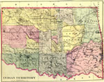
The Archives preserves nearly 1,300 historical maps, which are divided by origin into manuscript or state agency collections.
Later maps show the location of oil storage batteries and oil leases, mineral resources, timber and coal lands. These maps provide the researcher with a visual perspective on such topics as railroad routes, school sites, political boundaries, the highway system, oil pipelines, and water resources. Historical maps can illuminate as well as illustrate the historical landscape. Used in conjunction with other records, manuscripts, publications, photographs, audio tapes and video tapes, these maps are a valuable piece in the historical puzzle [please note that, for preservation purposes, these maps cannot be photocopied]. |
Return to Archives Collection Highlights
| Archives and
Records Links A&R Home Page A&R Administration, Rules and Fees Archives Division Records Management Division Land Records Service Contact Us |

Copyright �
- All Rights Reserved
Oklahoma Department of Libraries
Copyright � - All Rights Reserved
Oklahoma Department of Libraries

 The
former includes 19th Century maps of the Western
Territories detailing Arkansas, Missouri, Kansas, Texas, and
the Oklahoma and Indian Territories. They cover such subjects
as Indian nations, tribes and reservations, the pony express,
military forts, ceded lands, and cattle trails.